Showing posts with label amsterdam metropolitan. Show all posts

Zeevang

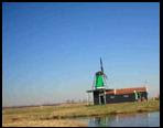
Zeevang, green town waterfront
Zeevang is a municipality in the Netherlands, in the province of North Holland. The municipality Zeevang is a relatively young town, which consists of the cores Beets, Oosthuizen, Middelie, Kwadijk, Hobrede, Schardam and Warder. Zeevang is an attractive town that has much to offer.
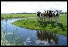
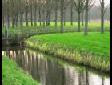
The town lies on the Zeevang Markermeer in the triangle-Edam, Purmerend Hoorn. The area is characterized by the watery nature, ribbon villages and openness. It is also advertised as open agricultural landscape with values in the area of landscape, nature, recreation and cultural history.
Zeevang a municipality has a relatively short history, the town itself is only since 1970. Yet there is much to tell about the history of the villages and hamlets which Zeevang exists. Zeevang is a "small" town with a low population compared to the vast territory. You will find more peace and quiet, rural scenery and a magnificent view over the IJsselmeer.
The municipality Zeevang is a vast, rural community located on the IJsselmeer. Zeevang constitutes a "green" link between the towns Hoorn and Purmerend. The historic sites Edam, Marken, Volendam and Beemster the World are a stone's throw away.

Zandvoort

visit to Zandvoort , stay in hotel or apartment and private home and villa
Zandvoort is a municipality and a town in the Netherlands, in the province of North Holland. Zandvoort is one of the major beach resorts of the Netherlands; it has a long sandy beach, bordered by coastal dunes. It is also the site of the country's most important automobile racing circuit, Circuit Park Zandvoort. There is a nudist beach located about 2 km to the south, with 6 cafés or restaurants; it extends several kilometers further south.
The municipality of Zandvoort consists of the communities of Bentveld and Zandvoort.
Zandvoort was originally a fishing village. That’s why Zandvoort’s coat of arms bears three golden fish. The seaside resort owes its name to its location. It used to be called Sandevoerde. ‘Sande’ means dunes or sand. ‘Voerde’ or ‘Voorde’ was the name for a shallow crossing, i.e. a ford. Zandvoort therefore means a shallow crossing in the sand. Since 1100, the village lay sheltered behind the dunes. Part of the town centre is still situated there. Even though today fishing is still a commercial activity in Zandvoort, tourism has become the most important source of income.
The French rule (late 18th, early 19th century) was disastrous for Zandvoort. The French occupying forces did not allow the fishers to set out to sea. Nor was it advisable to do so. Because France was at war with England. As a result, the majority of the Zandvoort population was unemployed.
However, the sea was not the only source of food. The dune soil proved to be fertile ground for growing potatoes. In the 19th century, Zandvoort was swept by a veritable potato mania. The dune potatoes became famous in the Netherlands and abroad. Mainly because it was a very tough plant. The potato disease was unable to affect the Zandvoort potatoes.
In the 19th century tourism started to flourish. The Badhuis (Bathhouse) was built in 1828. Suddenly, Zandvoort was easy to reach by means of a brick-paved road, the Zandvoortse Laan. Hotels, shops and luxury villas sprung up. And a railway connection was completed in 1881. That brought distinguished visitors to Zandvoort, among whom Empress Sissi of Austria. After World War II, building activities consisted mainly of residential housing and holiday flats. Today, Zandvoort annually welcomes some 4.5 million visitors from all walks of life.
Transportation
Zandvoort has a station, with half hourly services to Haarlem and Amsterdam, with extra services from Haarlem during the summer. The station is Zandvoort aan Zee railway station.

Zaanstad

Travel to Netherlands visit to Zaandam - Zaanstad
Zaanstad is a municipality in the Netherlands, in the province of North Holland. Its main town is Zaandam. It is part of the metropolitan area of Amsterdam.
Zaanstad is the fifteenth largest city in The Netherlands. The municipality was established in 1974 through the merger of seven villages. This feature makes Zaanstad unique: the dynamics of the city, the peacefulness of the villages and the extensive stretches of peat-meadow alternate in the Zaanstad landscape. This region has an industrial tradition of more than four hundred years, with many industrial monuments along the River Zaan as silent witnesses.
The municipality of Zaanstad consists of the following cities, towns, villages and/or districts: Assendelft, Koog aan de Zaan, Krommenie, Westzaan, Wormerveer, Zaandam, Zaandijk, 't Kalf, Kogerveld.
Recreation and tourism
The charm of Zaanstad lies in its variety. This attracts more and more tourists to the peat-meadow areas, the industrial monuments, the urban centre and the Zaanse Schans, which shows how Zaan villages looked one hundred years ago. In the immediate vicinity of the Zaanse Schans, the Zaans Museum is situated. The Zaan Region has enough to offer to spend several days visiting the different tourist sites. There is plenty to see in the town itself and visitors can take advantage of the region's surroundings: the towns and villages along the former Zuiderzee, the coast, the dune area and Amsterdam.

Working in the 21st century
In Zaanstad, some 16% of the population still works in industry. The food industry (including the large cocoa industry) is still prominent and Forbo Krommenie is the world's largest manufacturer of linoleum. The international retail concern Ahold grew into the Zaan Region's leading company. Many offices were developed in the vicinity of the Zaandam train station. These were occupied by a large number of companies coming from outside the region, because Zaanstad had become a vital component of regional economics and the job market. Office space is still available now, and there is space in the new industrial estates for industrial and service companies.
Living in the 21st century
As an industrial town, Zaanstad has many pre-war and post-war workers districts. In recent decades, new housing became more spacious and luxurious. Zaanstad has many new housing areas, often of high quality in terms of architecture, variety and their spacious lay-out. The desire to save as much as possible of the Zaan peat-meadow areas means that most of the housing needs to be built within the confines of the city. This is often done along the banks of the Zaan, when old businesses relocate. The municipal Zaan Banks project provides the structure for these activities. The basic assumption in the project is that the characteristic atmosphere of the historic town along the river is reinforced.
Effervescent town centre
Zaanstad wants to retain and strengthen its atmosphere of both a village and a town. Colossal steps have already been taken to reinforce the urban identity of Zaandam, the main village. Part of the centre has been turned into a pedestrian-only area, underlining its shopping and entertainment function and improving the atmosphere. The cultural level of Zaanstad improved substantially when the Zaan Theatre and smaller surrounding cultural facilities were opened in the city centre.

Wormerland

Wormerland - Zaanstreek
Wormerland is a municipality in the Netherlands, in the province of North Holland. The municipality has an area of over 4500 acres and is bordered by Beemster, Graft-De Ripe, Zaanstad, Oostzaan, Country and More Purmerend.
Wormerland is a vibrant, resilient community and forms the green buffer between the urban areas. With a diverse population structure and dynamics of balanced living, working and recreation, the town an attractive environment for both young and old.
The Zaanstreek is unique in the region of Amsterdam
The Zaanstreek derives its charm to a combination of peatlands, Zaanse typical wood construction, industrial monuments, the Zaan, village atmosphere and a heart. With a total of nine villages and one town is the Zaan contrasts with all well worth a visit.
The Zaan region covers three municipalities: Zaanstad, Wormerland and Oostzaan. Among the former are Zaanstad Zaandam city and the villages Krommenie, Assendelft, Wormerveer, Koog aan de Zaan, Zaandijk, and Westknollendam Westzaan.

The Zaanstreek is an enterprising region that gets the maximum from its main assets, watery landscapes and industrial heritage. The Zaanstreek plays an important role in the development of the Amsterdam region. This is so for centuries.

Wijdemeren

Wijdemeren is a municipality in the Netherlands, in the province of North Holland. Wijdemeren: an abundance of tranquillity and room for recreation in the Green Heart of Holland Wijdemeren is, with 7700 ha., the largest municipality in the area.
Wijdemeren it is a unique part of The Netherlands, with an abundance of lakes, swamps, forests, canals, meadows, estates, monuments en protected townscapes. Wijdemeren was founded in 2002 as a merger between the previous municipalities of Loosdrecht, ‘s-Graveland, Nederhorst den Berg, Ankeveen, Breukeleveen and Kortenhoef. Wijdemeren is located in what is called ‘the Green Heart’, a protected ‘green’ part of Holland, between the cities of Amsterdam, The Hague, Rotterdam and Utrecht, the geographical heart of Holland.
The municipality of Wijdemeren consists of the following cities, towns, villages and/or districts: Ankeveen, Boomhoek, Breukeleveen, 's-Graveland, Kortenhoef, Muyeveld, Nederhorst den Berg, Nieuw-Loosdrecht, Oud-Loosdrecht.

Ankeveen
Ankeveen is Wijdemeren’s smallest village. It is completely surrounded by swamps and lakes. It is an ideal spot for hiking, bicycling or canoeing. And in winter, if the lakes freeze over, it is one of the best places to be if you like ice skating on natural ice.
Graveland
Characteristic for ‘s-Graveland’s protected townscape are the beautiful estates surrounded by forest area. These estates originate from the 17th (Golden) century, when nine estates were built by rich merchants from Amsterdam. A unique estate is Gooilust. Once owned by Frans Ernst Blaauw, it contains an extraordinary collection of tropical plants and animals that were brought there by Blaauw from his travels to the former Dutch East Indies. The garden can be visited in summertime on Tuesday and Saturday afternoons. Located along the ‘s Gravelandse vaart are the dwellings of laundry workers who used to work in the laundry works that were situated here. These laundry works thrived because of the extremely clean and soft water in this area.
Kortenhoef
Kortenhoef is a picturesque little village surrounded by beautiful lakes. The lakes originate from the times when peat was cut from this area. It is one of the most often painted area’s of Holland. In fact, Kortenhoef’s Protestant church is the most often painted church in Holland.
Nederhorst den Berg
Situated on the river Vecht, Nederhorst den Berg is one of the oldest towns in the area. Already in the 12th century a church was build there on a natural sand hill to protect it from flooding. Nederhorst castle is situated right in the middle of town and the town’s name partly originates from this castle. Unfortunately the castle is not open to the public.

Weesp

Weesp is a municipality and town in the Netherlands, in the province of North Holland. The territory of Weesp is over 2000 years inhabited. Weesp its strategic location on the river Vecht, on the border of Holland and Utrecht, the city has acquired in the year 1355 town rights. Battle has always played a big role, first as a transport route and today especially for boating.
The municipality of Weesp consists of the following cities, towns, villages and/or districts: De Horn, Uitermeer, Weesp.
Weesp lies next to the rivers de Vecht and Smal Weesp and also next to the Amsterdam-Rhine Canal. It is in an area called the "Vechtstreek". It is only 3 km from the end of the Amsterdam metro, but the wide Amsterdam-Rhine Canal keeps it geographically separate. Weesp is a rail junction, and very easily accessible. The town is surrounded by open grassland.

Weesp a paradise for photographers. First: the mills, the fort, the silhouette of the city and then appear behind the trees along the High Street the stately houses. Moreover, from the towers of the churches.

In the old town of Weesp exchange bustle and rest apart. The quiet Old Canal and across its stores with its Metropolis. The Achtergracht her through traffic across the canal and the Roskamstraat. The Slijkstraat a busy shopping street nearly opposite the Medieval Middenstraat.

In Weesp you have the right to see ruins of the ramparts of the Old and New Holland Water Line and the Defense of Amsterdam. In the center is the tower Ossenmarkt fort, which was recently renovated. This fort lies within the fortifications of the fortress in the 17th century were built of Weesp to make a real fortress. If you follow the Vecht from the center to the south you'll fort against Uitermeer. The land surrounding the fort is accessible by foot and by boat.

Waterland

Waterland is a municipality in the Netherlands, in the province of North Holland. It is located north of Amsterdam, on the borders of the IJsselmeer. Waterland is a picturesque village which lies just above Amsterdam. Surrounded by meadows and water provides the necessary rest as opposed to Amsterdam.
The municipality of Waterland consists of the following cities, towns, villages and/or districts: Broek in Waterland, Ilpendam, Katwoude, Marken, Monnickendam, Overleek, Uitdam, Watergang, Zuiderwoude.
You can bike, canoeing, visit various monuments, going out for dinner or just a walk through the protected townscape. Many people inspired by the picturesque appearance of Broek in Waterland, shows that a relatively large number of artists in recent years have established in Waterland and galleries have opened.

Beautiful Homes
Waterland was in the seventeenth and eighteenth century the most prosperous town in Waterland. Many shipowners, captains and wealthy merchants left Amsterdam to live outside. The Broekers openly came out for their wealth and stately homes were built with beautiful interiors. In some houses, the monumental original interiors still on display. You can also recognize the houses in which they are painted pastel colors. In the period of poor Waterland houses were painted mainly in shades of gray. In the past, Waterland known for its cleanliness. Many travel descriptions of foreign tourists from the eighteenth and nineteenth centuries tell about it.
In the heart of Waterland, the vast majority of the buildings built before 1850. Until 1940, the construction activities limited. A house was usually occupied by several families.

Velsen

Velsen is unique and versatile
Velsen is a municipality in the Netherlands, in the province of North Holland. It is located on both sides of the North Sea Canal. Velsen-IJmuiden, situated along the North Sea canal, which discharges into the sea via enormous sluices, combines the peace of wide beaches and dune landscapes with the hustle and bustle of a fishing port, fish market and local industry.
The town is the heart of the Velsen IJmond region. With a unique location, excellent infrastructure and facilities, the town has much to offer residents and businesses. Velsen is a versatile town where the outstanding live, work and visit is. According to one authoritative study Velsen also belongs to the five most attractive towns of our country. Hilversum is among the top ten of the Dutch seaside resorts. And Spaarnwoude is considered one of the country's most popular nature and recreational areas.
The municipality of Velsen has over 67,000 people and has seven cores, which is the largest IJmuiden.
Each of those cores has its own character. Velsen and the town has a rich history.

trip through the area is already clear that the town was once a strategically attractive location. Brederode castle lay in the Middle Ages along a major trade route, the fort at Fort Island IJmuider guarded the locks on the North Sea since 1875 and was part of a known theorem of Amsterdam. In the Second World War laid the Germans here, even a bunker to line.

The origin of the town is the village Velsen, formerly a farming community between the dunes and the Wijker More. Al was here in the early Bronze Age settlement in the lagoon area, formed by sea walls and beach lakes. The Roman domination left its traces in the form of a port on the Wijker More.
The Church Velsense Engel Mundus was a mother of five churches in the county of Holland. The tower built in Romanesque style dating from the 12th century. In the 17th and 18th centuries, the dunes a favorite place for Amsterdam merchants, who acquired estates here and there built country estates. As Beeckestijn, Velserbeek, Waterland and steam turbines. These estates, in large part as accessible public park, the vast dunes, the wide beach and recreation area Spaarnwoude, Velsen to make a town attractive for tourism and outdoor recreation.

Canal, port and fisheries
The rural tranquility of the town came to an end, when the North Sea Canal opened in 1876. The IJ and above were more Wijker drained. Many canal workers remained and were now living, the staff with the locks and the customs, the first inhabitants. The new facility was named by King William III IJmuiden - mouth of the IJ. The town developed rapidly. Contrary to expectations, this was not the large shipping, but the sea after the favorable possibility of the safe harbor was discovered. At the end of the last century, a fishing port built by the state available, which later became rich established auction.
IJmuiden has become one of the major sea ports of landing in our country. In 1989, the State Fishing Port Authority became a separate company: Seaport IJmuiden NV.
The locks consist of four shipping locks, built in 1874, 1896 and 1929. The Noordersluis, with a length of 400, a width of 50 and a depth of 15 meter, has long been the largest in the world. In the sixties the harbor and channel renewal.
Beach
A whole new, attractive situation arises in the south pier of IJmuiden. The beach of Hilversum is brought closer to the sea. And there is a marina built, Seaport Marina, in open connection to the sea state. There arose a new boulevard along with shops and restaurants. South of it lies a lake.
There is ample parking. All this was possible because of natural causes on the outside of the south pier still more land arose. The boulevard is a hotel risen. Along the dunes between the beach and marina of Hilversum apartments for sale are built.

Uithoorn

Uithoorn originated in the Middle Ages as a river town on the banks of the Amstel. Uithoorn is a municipality and a town in the Netherlands, in the province of North Holland. The municipality of Uithoorn consists of the following cities, towns, villages and/or districts: De Kwakel and Uithoorn.
Uithoorn The name (originally "Ute Hoirne ') means the" corner "and is the final piece of land between the lake and the Amstel Zijdel. The peat bog in the river behind the dam formed peat lakes.
In the 18th and 19th century saw the reclamation of the land on which ponds water was captured. Thus in 1770 was around the Bovenkerkerpolder dry, Thamer Binnenpolder in 1851, the North in 1877 and in 1883 the South Legmeer Legmeer. It settled farms and therefore had to develop a new impetus Uithoorn.

The development of Uithoorn was well underway by 1915 in connection with networks (train-Nieuwersluis Haarlem) and by the completion of the provincial road-Haarlem Hilversum in 1942.
After 1945 Uithoorn has developed rapidly. This development was mainly due to the strong economic growth in the southern part of the Amsterdam region.
Related to housing problems of the workers in this region from 1950 until the 70 years in a constant flow of many houses built.

Uitgeest

Visit to Uitgeest
The municipality of Uitgeest consists of the following cities, towns, villages and/or districts: Assum, Busch en Dam, Groot Dorregeest, Uitgeest.
Uitgeest city is a municipality and a town in the Netherlands, in the province of North Holland.

Uitgeest No less than five windmills can be seen in the polder landscape surrounding the village. Uitgeest was the birthplace (in 1550) of Cornelis Corneliszoon, inventor of the wind-powered sawmill.
The village has a Reformed church dating back to the early 14th Century, as well as a kart-racing track and lakeside marina. Fort aan den Ham (between Uitgeest and Krommenie) was one of the 42 forts of the Stelling van Amsterdam, a 19th Century ring of fortifications around Amsterdam which has been designated as a UNESCO World Heritage Site. The fort is now a museum open to the public on Sundays.

Uitgeest "A very pretty village. It's recommended to rent a bike from a local bike shop. This is usually a very cheap rental but deposit is (2006) 100 euro per bike. Lake on outskirts past marina is excellent for swimming and very safe for young children as a child-friendly area is cordoned off. Train station and excellent bus service provide access to neighboring areas and Amsterdam.
Railway station: Uitgeest
Uitgeest is served by 4 trains per hour (Monday - Saturday), journey time to Amsterdam is around 30 minutes. It is recommended not to travel on the Stoptrein via Beverwijk and Haarlem as this journey is slower, and the journey via Zaandam passes through beautiful countryside.

Purmerend

Visit to Holland and buy Souvenirs
Purmerend is a municipality and a city in the Netherlands, in the province of North Holland. Since the early 1960's, Purmerend has encountered its biggest transformation: in 1955 it had less than 10.000 inhabitants, now the count exceeds 75.000. A lot of the new citizens have migrated from the nearest capital of Amsterdam. Reasons for this migration were obvious: many were looking for a more spacious and comfortable place to live near Amsterdam, and for a better and safer location to raise their children. To accommodate them, Purmerend has built several new areas around the historic town center. The last development, 'Weidevenne', is still in progress.

In the thirteenth and fourteenth century, Purmerend used to be a small fishing-village amidst rural surroundings abundant of water.
This changed in the years to come. In 1410 Purmerend was given municipal rights and in 1484 it gained market privileges. After the reclamation of the surrounding lakes Purmer, Beemster and Wormer in the seventeenth century, Purmerend became important as a market and trading town. For several smaller communities around it, the city of Purmerend has been a social meeting point throughout history and the centre of agricultural trade. Between 1572 and 1645, the population multiplied by a factor five. In this period, ramparts and canals were created and the small rural village evolved into a town.
The city centre as we know it today was formed in this era. In 1824 the Noord-Hollands Kanaal was opened (on the West Side of Purmerend), providing the possibility for ships to sail from Amsterdam to the north of the province.

Urban development
In the 1950s, Purmerend received the assignment by the government order to build a certain number of houses to accommodate people from Amsterdam (new town assignment).
Around 1995 the term new town assignment changed into VINEX-assignment (assignment according the extra 4th Bill Housing planning). This resulted in creating 6.500 new houses in the development 'Weidevenne'. 5.400 of the houses concerned have already been built. Final realization of the VINEX-assignment will be in 2008.
On January 1st 2005 the number of houses in Purmerend was 32.275. It's expected to be 35.107 in the year 2010.
The infrastructure around Purmerend includes a four-lane freeway stretching from Amsterdam to Leeuwarden. The facilities for public transportation are quite extraordinary, especially to and from Amsterdam. Many bus routes to Amsterdam use separated bus lanes. Every single working day, these buses carry over 20.000 commuters and other civilians to (the center of) Amsterdam.
Purmerend also has a direct railroad connection to Amsterdam, carrying another 6.000 of Purmerend's citizens a day. At this moment Purmerend has two railway stations. In 2006, a third railway station will be operational in the area of Weidevenne.

As mentioned before, Purmerend has a very 'green' character.
Along the eastern town border there's the 'Purmerbos'. It is a park covering 700 acres.
Close to the town center, is Leeghwaterpark, covering about 100 acres. Besides those two, Purmerend has 7 smaller parks in all the different areas of the town.
On a cultural level, Purmerend has a theater "De Purmaryn" with a total capacity of 630 visitors. Purmerend also has a movie theater. The construction of a popular-cultural facility is in progress. It will be completed in the latter part of 2005.

Districts
Purmerend is made up of the following districts.
* Centrum ('het stadje')
* Zuiderpolder
* Overwhere-Noord
* Overwhere-Zuid
* De Gors
* De Gors-Zuid
* De Gors-Noord
* West
* Purmer-Zuid
* Purmer-Noord
* Wheermolen
* Weidevenne
* Baanstee-West
* Baanstee-Oost
* Baanstee-Noord
* De Koog
* Molenkoog
* Hazepolder

Ouder-Amstel

Sightseeing Holland visit to Ouder-Amstel - Ouderkerk aan de Amstel
Ouder-Amstel is a municipality in the Netherlands, in the province of North Holland, partially within the municipality of Ouder-Amstel and partly in the municipality of Amstelveen (the western part of the river), at the place where the issues Amstel flows into the District.
The village is located south of Amsterdam, Amstelveen and slightly east of north of the border with the province of Utrecht. The population is approximately 8228 (January 1, 2005). There are 269 companies with which 60 farms. Most of the village lies east of the Amstel River in the municipality of Ouder-Amstel, it is the center of the village and is also the town.

Ouder has an old and new part. The old part has a rich cultural heritage, with a 18th century Reformed Church, a 19th century Gothic Revival Catholic church (the Church Urban) designed by Pierre Cuypers and the centuries-old Portuguese Jewish cemetery Beth Haim with - the Netherlands - unique sculpted tombs.

It is likely that in this place of the lords of the castle has been Aemstel, from which it is mined and Amsterdam Amstelland created. Ouder about two centuries older than Amsterdam. The Lords of Aemstel were vassals of the Bishop of Utrecht and later the counts of Holland. They are several times rebelled against their lords, but that was not well off.

In the old part of Ouder are many restaurants and shops. The new section consists of a residential area and a marina.
North of Ouder located along the Oudererdijk the polder De Zwaan.
Ouder located south of the polder the Round Hoep. The button on the polder dike through Wavre is popular with cycling and walking Amsterdam. Other recreational facilities are rowing on the Botshol, and entertainment on the water Oudererplas, which occurred 60 years after the sand pits that have been made for the construction of the A9.
Ouder a stop along the Zuidtangent, a high speed bus in the direction Haarlem (via Amstelveen, Hoofddorp and Schiphol) and Amsterdam Zuidoost.
Comments

Oostzaan

The municipality Oostzaan is a small town in province of North Holland Netherlands, Geographically, the 'sandwiched' between Amsterdam, Zaanstad and Country More. The town has a green and rural character by the presence of unique natural area as the peat "The Oostzanerveld 'and Recreatigebied' t Twiske.

The green character plus its great location in relation to Amsterdam and Zaanstad, but also the rest of the region through the A7 and A8 and public transportation (bus 92), Oostzaan makes a very pleasant town to live and work.

Recreatigebied' t Twiske. located north of Amsterdam between Purmerend and Zaanstad. The area is 650 hectares and consists of one third water. Recreation Twiske It manages the recreational facilities that have been built. Besides nature, hay fields and pastures have been specially designed for daily recreation. The Stootersplas is a number of beaches which one is for naturists. From the parking there are several hiking routes, but also for cyclists and horse riders have plenty of options. Dogs are special outlet where they can run loose. All services are free.

In Roemer, the port can sailboats, rowboats, canoes and bicycles for hire. There are also
options for sailing, rowing boats, canoes and surfboards. When renting a berth for your sailing, rowing boat or you can choose from a berth in a box (water) or a berth on the side. Through a slipway use your own boat launching. At the port office maps and brochures available. Moreover, there is a multifunctional room that can be rented for meetings, courses etc.

Naarden

Visit to Naarden
Naarden is a municipality and a town in the Gooi region in the province of North Holland in the Netherlands.
Overall : Naarden is Its strategic, but also vulnerable location Naarden has a rich and special history. Naarden has one of the coolest and most original fortifications of the world that have been preserved. Thanks to extensive restoration was well preserved original character. This makes Naarden one of the finest Dutch cultural monuments.
Naarden was granted its city rights in 1300 (the only town in Het Gooi to have been done so) and later developed into a fortressed garrison town with a textile industry. Naarden is the home of the Netherlands Fortress Museum (Nederlands Vestingmuseum). Every year Naarden hosts the national photograph festival and, on Good Friday, a performance of Bach's St. Matthew Passion in the local church, which is called the Great Church or St. Vitus Church. Despite its earlier importance, Naarden population size was surpassed by Hilversum in the 18th century and today is smaller than its neighbour Bussum.

Muiden

Muiden and Muiderberg Holland
Muiden is a municipality and a town in the Netherlands, in the province of North Holland. It lies at the mouth of the Vecht and is in an area called the Vechtstreek.
Attractions
* Muiderslot (Muider Castle), a well preserved castle from the Middle Ages
* Muizenfort, (Mice Fort) a 19th century fortification part of the Stelling van Amsterdam
* Pampus Island, an artificial island also part of the Stelling van Amsterdam

History
Already in the first centuries after the beginning of our era was an important trade Fighting between northern Germany and Flanders. On her mui (mouth) formed an early settlement.
Utrecht before 1000 was an important trade and Muiden seemed destined to produce a port to be equally important.
History has however taken a different course.
Around the year 1200 Bishop Otto II gave the area, which is Muiden and that part of the possession of St Martin in Utrecht, with its vassal of Gijsbrecht Aemstel. In the years that followed was all too often Muiden arena of clashes between the counts of Holland and Gelre, at the expense of the areas along the Vecht tried to extend their power.
Party Quarrels in the diocese led to it, the Lord of Aemstel and the Bishop of Utrecht declared war on each other. With the support of Gijsbrecht's arch-enemy, Count Floris V of Holland, Bishop won the battle. He rewarded his ally by real estate, which also belonged Muiden. It is probable that Floris V was the builder of the Muiderslot.
Although Floris V few years later - when Hakkelaarsbrug - was murdered, Muiden continued possession of the counts of Holland. Economic has caused irreparable damage to Muiden it is the impact of this change of ownership never recovered. The conversion to fortress, focusing on the defense of Amsterdam, ended Muidens importance as a port of Utrecht.
Two centuries later, in 1500, was Muiden occupied by no more than 500 to 600 people, almost all in needy circumstances, have found their livelihoods in fishing for eels, keeping a few cows and weaving rush mats. Wealthy people did not. So poor was the town that the town council in 1611, when a fire had lost all wooden houses do go, four thousand guilders had to borrow from Amsterdam to the worst suffering of the destitute Egyptians Muiden needs.
Only after 1600, when a boom in the country emerged as a result of operating on foreign continents, also flourished in Muiden, it settled several new businesses.
Salt works yielded salt for shipment to the Baltic countries. Amsterdam brewers realized that the good Fight Water was a better material for their product than their brackish canal water and moved their business to our town. It was in imitation of Weesp, which at this point enjoyed a reputation, a brandy distillery.
In 1621 the first shipyard was put into operation, there soon followed a few. The First British naval ships, the demand for good until loose. There was a ropewalk for the required rope and a taanderij. Furthermore, a soap works, a flour mill, a distillery and a lime glass works. It would be wrong is about the size of these companies to make a big performance. The Town Council was happy to play Danish veekopers, who had chosen as Muiden unloading their Danish oxen, the trade took place at the Ossenmarkt.
The Muider and Naarderstraat Trekvaart dating from 1640, but they stayed by the lack of locks to 1663 with no connection to the Vecht. All goods should be loaded by stevedores.
Many street names in our present new districts are from the famous companies of the time. The Anchor, the Duyf, Long Gangh, Lily, the Peacock and the Blue World to remind saltworks around 1700. The deer and never had Exchange names of shipyards. Smelt is the name of the extract from the grain mill, Muiden (around 1800). In 1702 a powder mill was built, after Amsterdam had refused permission to rebuild the factory exploded in 1700 at the Amstel.
A quarter century, from 1815 to 1840, many emigrants boarded themselves, and most Swiss Germans, Muiden to their emigration to America.

Modernity makes its entry in 1880 as a Hagenaar obtained the concession for the construction of the Gooise Muiden by Tram, which in World War II remained in operation. In 1894 the Amsterdam-Rhine Canal was finished.
It made the highway Fight as unnecessary and meant for many Egyptians Muiden the end of their padding. Amsterdam was popular as a working city, the steam made it possible to go commuting.
Once more it was silent, then in 1927 by the construction of the temporary bridge, just south of the present traffic of the highway to Amsterdam Naarden not through the narrow and Naarderstraat Sluisstraat and the toll bridge Vecht have to drive.
The toll was shifted to the new bridge, but was abolished in 1929.
The image of Muiden has, like that of many other places, in recent decades rapidly changed. The extensions outside the old core, it helped greatly. The water, with everything that goes with it, has made his mark on Muiden. Tourism attracts many people today to the cozy harbor town Muiden.
The growth of Muiden obviously reflected in the increase of its population: in 1900 counted Muiden Muiderberg together and no inhabitants in 2000, there were approximately 3500 to 1950, in 1978 the number of 7000 passed. Meanwhile, the number dropped back below 7000.

Muiderberg
As with the earliest records dating Muiden Muiderberg the end of the thirteenth century. The Holland Count Floris V in 1280 was vassal of this area. After his capture he was in 1296, when an escape attempt from the Muiderslot murdered by political opponents.
Of the present Dutch Reformed Church should be said that they historical ground. In 1324 it was here, to read H. Masses for the soul of peace Count Floris, a chapel and forty years later a church.
It seems incredible to us that this place used to be the center of the village was. But the former Zuiderzee has, driven by strong northwesterly winds, centuries large tracts of land washed away. Only in 1916 the seawall was sufficiently strengthened to the lowlands, to the city of Utrecht, flood of activity.
Muiderberg was long time not much more than four great outdoors: Mountain Huize, Wisseloord, Hofrust Rust and Empire. The latter stood in the place where the echo is now. The name Mountain House of still lives on in the farm of that name on the Brink. The owner of Wisseloord left on his two main roads, which were named after his son and daughter. They are Willemslaan and Pauline Avenue.

The Right House at the entrance of the village was a half century ago, a sort of auxiliary district where local disputes were tried. The actual building was right in Naarden, the capital of Gooiland.
Muiderberg that largely consisted of sand, was the rapid expansion of Amsterdam especially helpful. The transport of sand to the capital took place on the canal and to Muiden Diemen, mainly to transport the sand was dug in 1640. Especially along the Googweg much sand is dug away, the steep boundary of the Dutch Jewish cemetery is still visible, how far it three centuries ago with the excavation went.

In 1880 became a branch of the Muiderberg Gooise Tram, it was a modern connection to the surrounding areas in the Gooi created. The barge fell into disuse.
The Tram Gooise drove over today by Gerard Doulaan Naarderstraat the polder to the old causeway. In the Second World War the line was lifted, but it is certain that the presence of the tram has had a major impact on the population. In the first fifteen years has doubled, from 200 to 400 people.
Since the century is again five times. Muiderberg has around 3200 inhabitants. Now the plan out Dijke few years ago is completed, the population will stabilize or even decline slightly.

Laren city

Laren is a municipality and a town in the Netherlands, in the province of North Holland. Located in the region called 't Gooi, it is the oldest town in that area. It is one of the richest towns in the Netherlands, along with its neighbour Blaricum. Nationally, Laren is well-known for its wide array of clothing shops.

Laren The village lies in the heart of the Gooi. It is the oldest town in the Gooi. The original name is Laer, meaning "open space" means.
8000 years ago lived on the place where now the South Heath is situated in the northern nomads coming with their reindeer. Later, approximately in the middle of the Bronze Age (1500 BC). Laren and area residents include the Beaker culture (the name comes from the shape of the pottery that they used).
The Western and Southern Heide are tumuli (burial mounds) are present. The South Heath near 't Bluk are seven of these terpjes, known as the Seven mounds. Still later appeared and disappeared successively, the Celts, Teutons, Franks, Angles, Saxons and Frisians. Around 400 farmers settled to the east of the present St. John's Cemetery. This outstanding eng (land), near the sports fields of LVV, the village is the birthplace of Laren. The repeated invasions and wars farmers have pulled back into a neighborhood in case of emergency assistance to each other can easily provide. This place is the present seven. Later we dropped down to the lower part of this place, now called the "Brink". The pool there was never dry and was mainly used as for watering livestock. This was the typical pond this exact Coeswaerde "derived from" Koewade "(Wade: watering). From this arose the present Laren.

Landsmeer

Landsmeer is a municipality and a town in the Netherlands, in the province of North Holland.
Landsmeer is Land Lake, a rural town green, with over 10,000 inhabitants, between Amsterdam, Zaanstad and Purmerend. Surrounded by protected nature reserve.
Landsmeer town where the green of the peat land area and the blue of ditches, canals and ponds extra color to the red ribbon of the building. A beautiful living environment. A town with busy people.

From playing sports to rural artists of various kinds. International companies to regional services. Here you have a garden or garden area, a boat on the door for fishing or rowing through nature. And around the corner the benefits of achieving good urban environment. Amsterdam, Purmerend, Zaanstad, something for everyone.

Together with the settlements and Den Ilp Purmerland More Land is a municipality since January 1991. The town has two major nature reserves within its borders, half of the recratie and Twiske The nature and the whole nature Ilperveld.

Water for present and past of a country more important role. Even the name of the original settlement refers to them. More land - along the lake. The fight against the water was too often lost. Dykes and flooding destroyed what was built with great regularity and at one point became even more country was completely isolated and not accessible by land.
Country is now more easily accessible from the Northern Ring Amsterdam and serves as a base for recreational day on or around the water. The "eternal enemy" has finally become friends.

Huizen

Huizen is a municipality and a town in the Netherlands, in the province of North Holland.
The name "Huizen" is Dutch for "houses" and this usage has been linked to the belief that the first stone houses in the region appeared here
is known as a former fishing village, although only at the end of the seventeenth century, the fishing one of the main means of existence was. This was particularly agriculture and cottage industry a major source of life. Houses in the fourteenth century got its name because it, reportedly, the first town in the Gooi was that the stone houses had

The fishing had its flowering in the nineteenth century, especially in 1854 when finally a port in use could be taken. Huizen was one of the major fishing sites around the Zuiderzee. About 190 fishing boats had homes as home. At the end of the twentieth century had been fishing quite less and the construction of the Afsluitdijk gave the final blow. The village saw the future, especially after the cheesemaker.

Hilversum

Hilversum is a municipality and a town in the Netherlands, in the province of North Holland. Located in the region called "'t Gooi", it is the largest town in that area. It is surrounded by heathland, woods, meadows, lakes, and smaller villages. Hilversum is part of the Randstad, one of the largest conurbations in Europe.

Hilversum It’s surrounded by nature, which makes it an ideal place to stay. The surrounding forests, heath and cultivation make it a prefect area for bike rides or long walks. The scenery is very diverse. The centre of Hilversum is remarkable as well, especially its architecture. The city’s architect Willem Marinus Dudok has put his mark on the town in the first half of the twentieth century. One of the most prominent buildings worth seeing is the city hall, where the town is governed. You can visit the premises if you make an appointment upfront.
Hilversum is the media capitol of the Netherlands. Practically all of the television networks and studios are situated here. A remarkable attraction is the Dutch Institute of Sound and Vision. It looks astonishing on the outside and the inside presents an historical masterpiece, for it keeps record of all of the still existing Dutch television and radio broadcasts.

Transportation
Hilversum is well connected to the Dutch railway network, and contains three stations:
* Hilversum railway station
* Hilversum Noord railway station
* Hilversum Sportpark railway station
The best links are from Hilversum railway station, as this is an Intercity station.

Heemstede

Heemstede is a municipality and a town in the Netherlands, in the province of North Holland. Heemstede city it is close to the capital city Amsterdam, to Schiphol Airport and to the North Sea coast. The majority of the working population works outside Heemstede. The service sector is the largest employer within the community. Heemstede is a green belt municipality with attractive shopping facilities and offering numerous cultural, sporting and recreational facilities.

Heemstede was founded in the 13th century. Floris the Fifth, Count of Holland loans fiefdom of the manor to Reynier van Holy, a knight from Vlaardingen. He may use the name Lord of Heemstede and has a castle built on the banks of the river Spaarne. The origins of the name Heemstede are not clear. "Stede" means "place" and "heem" means "house". So the name Heemstede might possibly mean "the place where the house is". The present coat of arms is based on that of the Holy family.


Development and growth
In the 17th and 18th century numerous country mansions are built in Heemstede. Wealthy families from Amsterdam and Haarlem spend the summer months in residences they have built there. Around 1650 there are some 28 country mansion residences, offering welcome employment to the local community.
The present municipality of Heemstede originated in 1813 and was then an impoverished community. The difficult economic situation during the French occupation of the Netherlands leaves its mark on Heemstede too. The number of laundries and bleach-works gradually dwindles. Those which remain make increasing use of steam machinery with increasing unemployment as a consequence. The mid 19th century sees bulb growing in vogue in Heemstede. Growers export their tulip bulbs all over the world.

A home for commuters
Things begin to look up around 1900. The advent of the train and the tram enables people to live outside the big cities whilst still working in them. Heemstede rapidly develops into a dormitory community with a fast-growing population. A new Town Hall is opened in 1907. Bulb fields become building sites. In 1912 the City Council develops a plan for the extension of Heemstede. Between 1900 and 1940 complete new housing estates spring up.
In 1913 the council purchases a centrally situated woodland estate and opens it to the public. Groenendaal Woods attracts many thousands of walkers annually from Heemstede and the wide vicinity. It is a popular destination all over the Netherlands for school trips. The children's farm and the playground attract younger visitors. For a number of years the woods have been managed ecologically.

In the 1930's the Heemstede Sports Ground was developed with football, hockey and baseball pitches. Heemstede also has swimming facilities, a sports hall, tennis courts and many facilities on the social, cultural and scouting front as well as for the elderly. The "Oude Slot" cultural centre hosts small-scale musical, theatrical and cabaret performances. There are also regular exhibitions.

Heemstede is a pleasant place to live. Since the end of the Second World War every available area of Heemstede has been developed. There are very few areas left for residential development. The result is a relatively elderly population. For many years the population total has hovered around the 26,000 mark. It is very difficult for young people in Heem-stede to find a place of their own to live.

Every bit as important is the traffic problem in Heemstede. The lack of a ringroad system means the Heemstede road network is overloaded. A solution is difficult to find in the short term and requires considerable creative thinking on the part of the government departments involved.
Despite these problems, life and leisure in Heemstede is good. The local council aims to maintain and cement Heemstede's position as a top location in Zuid Kennemerland and works hard at the upkeep of high quality facilities.